Martin's Point Bridge
Historic Points on the River
This hand-drawn map was created by Ford Reiche, a resident of Cumberland whose family has been in the state since the 1630s.
The Presumpscot River Dams
The Smelt Hill Dam, the first upriver dam from the Martin’s Point Bridge, was removed in 2002, which revealed the Presumpcot Falls for the first time in several hundred years. Portland Trails has purchased land along this segment of the river to protect it, and trails have been built down to the falls. These trails can be accessed (where).
No other river in Maine has had virtually all of its hydraulic head developed with dams. Until the removal of the dam at Smelt Hill, there were ten dams impounding 22 of 27 miles of the river. In 2013, fish passage was installed on the next dam upriver, the Cumberland Mills dam. There are currently 8 remaining dams on the Presumpscot River, making the river essentially a slow-moving lake.
Working downstream from Sebago Lake they are as follows:
Head, Eel Weir, Great Falls, Dundee, Gambo, Little Falls, Mallison Falls and Saccarappa Falls. All are owned by South African Paper and Pulp Industries (SAPPI), except for Great Falls which is owned by Florida Power & Light. All are also hydro-power generating except for Head and Cumberland Mills.
According to its licensing agreement with the Federal Energy Regulatory Commission, Sappi must provide fish passage at each dam above the Saccarappa Falls dam once each dam reaches specific numbers of returning sea-run fish.
Restoring historic runs of sea-run fish will help boost the health of Casco Bay and restore fish stocks in the Gulf of Maine, as herring and shad are important forage foods for other fish.
More about the River
Short by most standards, the Presumpscot rolls twenty-five miles, from Sebago Lake to Casco Bay, passing through Windham, Gorham, Westbrook, Falmouth and Portland. However, in that short distance it drops over 270 feet.
Even though the river is short, its impact is great. With a watershed of 648 square miles, the Presumpscot is the largest freshwater input into Casco Bay.
The river embraced vast amounts of river spawning Atlantic salmon, shad, and alewives as well as being home to land-locked salmon, brook trout, and the now extinct Presumpscot Jumper. In 1650 it was noted that, "...at certain times, the entire surface of the river for a foot deep was all fish."
In its natural state, the Presumpscot was both beautiful and bountiful.
No longer seen as a river destined to be defined by man's use, with careful stewardship the river can move to a rebirth of its once original beauty and bounty.
Information courtesy of Friends of the Presumpscot River - http://www.presumpscotriver.org/
Sturgeon In the River
Shortnosed Sturgeon have been endangered (under the federal Endangered Species Act) for many years. Gulf of Maine Atlantic Sturgeon were listed as threatened in 2012. Atlantic Sturgeon further south were listed as endangered in 2012.
The Casco Bay Estuary Partnership commissioned a Presumpscot fish assembly study in 2008. This study included a one-day electrofishing survey above the head of tide, so it did not look at the tidal portion of the river, where most sturgeon would reside. But as two species of sturgeon were captured just below Presumpscot Falls, it is likely that the species are fairly abundant downstream. The link to the full study is below:
http://www.cascobay.usm.maine.edu/pdfs/presumpscot%20_final_revised_report_20090731.pdf
Martin’s Point Bridge Photos from the MaineDOT Archives
- Several photos of the bridge from various time periods and vantage points
- Photo of the bridge as a draw bridge (1943)
- The First Martin’s Point Bridge and What it Cost to Cross (clip from PPH showing costs for toll bridge)
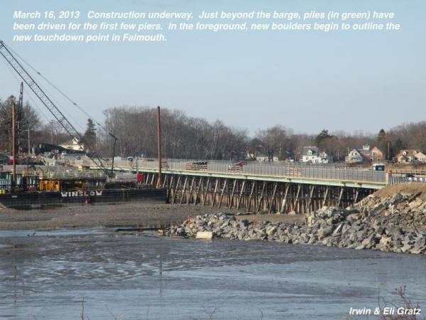
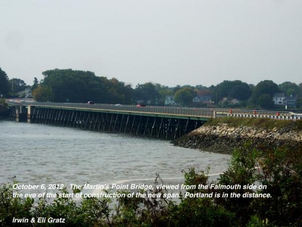
Construction Photos of The New Bridge