
2013 Comprehensive Plan
On February 7, 2014, the State of Maine approved the Town’s Comprehensive Plan. This approval is based on a set of draft changes that staff prepared and submitted in response to State review comments since the Council’s adoption of the original plan on October 28, 2013. On February 24, 2014, the Council unanimously re-adopted the plan inclusive of these revisions.
Since 2014 the Town Council has been working on implementation of the 70 action recommendatiosn contained in this plan and has made the Comprehensive Plan the cornerstone of its Annual Work Plans.These work plans are reviewed and updated each summer. Various committees have been assigned to work on specific tasks. Below is a chart that shows the current status of the implementation effort.
Volume I: The Plan (3.9 MB, 73 pages)
Volume II: Appendices (3.3 MB, 134 pages)
Notes:
The spreadsheets on PDF pages 123-134 are best printed on 11 by 17 inch paper.
The Fiscal Capacity Chapter was updated on May 1, 2019.
Volume III: Maps (21 MB, 27 pages)
Note: Large file! Please be patient when uploading. The maps on PDF pages 8-27 are best printed on 11 by 17 inch paper.
State of Maine approval letter (incl. Review Comments), dated February 7, 2014
Implementation Status, July 11, 2017
Contents of Volume I: The Plan
Cover Letter
Executive Summary
Introduction and Vision
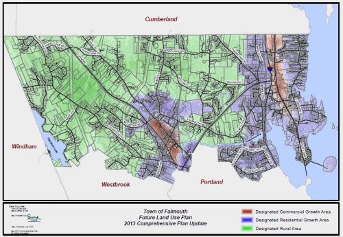
Future Land Use Plan
Regional Coordination Program
Capital Investment Strategy
Issues, Goals,Policies, and Strategies
Implementation Strategies
Plan Evaluation
Contents of Volume II: Appendices
Appendix 1: Implementation of 2000 Comprehensive Plan
Appendix 2: Public Participation Summary
Appendix 3: Survey Results
Appendix 4: Inventory Chapters -
Population and Demographics
Local Economy
Housing
Transportation
Public Facilities and Services
Utilities
Fiscal Capacity and Capital Investment Plan
Natural Resources
Marine Resources
Recreation and Open Space
Agriculture and Forestry
Historic, Archaeological, and Cultural Resources
Appendix 5: Timeline of Falmouth Planning Reports
Appendix 6: Image Sources
Appendix 7: Implementation Action Spreadsheets
Contents of Volume III: Maps
Mapping Sources
Current Land Use
Future Land Use Plan
Residential and Commercial Growth, 1990-2011
Potentially Developable Land
Natural Resource Limitations
Preferred Sewer Expansion Possibility in Growth Area
Areas of Potential Zoning Review
Pedestrian and Bicycle Transportation
Town Facilities
Utilities
Natural Resources
Water Resources
Publically-Accessible Recreation Facilities
Marine Resources
Agricultural and Forest Resources
Historic and Archaeologic Resources
Zoning
Town-Wide Resource Conservation Overlay Zoning Districts
Shoreland Zoning
Coastal Bluff Hazards (Shoreland Zoning)
For more information
Please contact Theo Holtwijk, Director of Long-Range Planning, email or 699-5340, or stop by his office on the second floor, if you desire to receive a printed copy of the plan. A paper copy of the plan is also available for review at the Falmouth Memorial Library.
Please contact Theo Holtwijk, Director of Long-Range Planning, email or 699-5340, or stop by his office on the second floor, if you desire to receive a printed copy of the plan. A paper copy of the plan is also available for review at the Falmouth Memorial Library.
Thank you for your interest.